


The Genesis of The Corner
- iamdavewave@hotmail.com
- May 12, 2021
- 5 min read

In a city of such natural beauty it's ironic that the most popular and most consistent surf-spot in Wellington is the result of one of the ambitious civil works schemes in New Zealand's history. It is An artificial surf spot. Here is a look at the Genesis of The Corner.

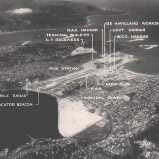
The Proto-Corner during the construction of The Airport at Rongotai, mid 1950's. The interference pattern that creates The Corner peak can be seen about halfway down the wall.
Lyall Bay before The Airport.
March 7th 1915 was the day when Duke Kahanamoku first introduced modern surfing to Wellington at Lyall Bay. At that time the beach made a graceful curve to the East as it still does now to the West. There were still large sand dunes and only a few houses. It is hard to imagine that there were any waves of much quality to be had where the Corner resides today.

Lyall Bay in 1909, six years before The Duke arrived. Waves are breaking in the area known now as "The Clubs". The Corner does not exist, instead the bay ends in a sheltered cove in its Eastern end. (Godber Collection, Alexander Turnbull Library)

By the 1930's almost the entire isthmus was covered in houses, with the exception of the Rongotai Aerodrome. The cove in the eastern end of the beach would have been offshore in the southerly, but there is no evidence that decent waves ever broke there. The reef where the breakwall sits now would have blocked most of the swell energy to the cove. There is some speculation as to there being waves off the breakwall reef, but it is hard to tell from the available photos. Any waves there would have been completely chopped up by the prevailing northerly, much like what happens at The Island.


Here's a collection of pics of the pre-airport Lyall Bay. It would have been quite a beautiful area before the sand-dunes were levelled.
The planning and construction of the airport
As early as 1928 it had become apparent that Wellington needed a better airport. Aircraft were getting bigger, air travel was becoming more popular, and the city was growing. On top of all this the city's central location made it an obvious choice to be a major hub for domestic air travel in New Zealand. This was well before the genesis of any environmental movement in New Zealand, and also it was a time when the interests of Tangata Whenua were not seriously considered. The Public Works Act had sweeping powers. There was some opposition from various groups, but once the decision had been made there was not much people could do about it. It's hard to imagine such a project being able to proceed today without a monumental fight. Of course you'd be hard pressed to find people these days who would tell you they don't think the airport should have been built where it is now. There just aren't any serious alternatives within a reasonable distance from the city.
In 1950 the decision was finally made to proceed with the project. The plan was ambitious. 180 houses and three industrial buildings would need to be shifted or demolished. A large hill would need to be levelled and three million cubic metres of fill moved. 32 Hectares of land would be reclaimed in Evans Bay and new roads constructed. The urban landscape of Rongotai and Strathmore would be permanently and drastically altered. Finally and of most interest to surfers, the entire eastern end of Lyall Bay was to be filled in and an over 400 metre long mole constructed.

The first step for the Lyall Bay reclamation was to construct the breakwall at what would become the end of the runway. Construction was aided by the natural reef at this point. 3268 concrete blocks were placed and over 22000 cubic metres of concrete was poured. Once the breakwall was completed the mole made its way back towards the beach. This wall was protected from the waves by 1500 tonnes of interlocking sheetpiling. Once the mole had made it to the beach from the breakwall there was for a short time a lagoon created. The lagoon was duly filled to accomodate the runway.*


In the third image here, circa 1959, the Corner appears to be all systems go. Too small an image to tell if there was anybody surfing that day.
In 1959 the airport was complete. From the images I can find it appears The Corner formed pretty much straight away. It is probably safe to say that the engineers who designed the airport had no idea of the significance to future generations of what they had created. At this stage I do not know who were the first people to surf out there, but in researching my next article I hope to find out. Surfing in the late 50's in Wellington was well and truely a minority pass time. It wasn't till the early sixties that it really took off. We can deduce that for a number of years The Corner would have been uncrowded.
What makes The Corner work?
The Corner surf break is what is known as a constructive interference wave. More commonly known in surfing terms as a wedge. The swell bounces off the wall and reinforces the swell line forming a peak. Perhaps the most famous example of this phenomenon can be found at The Newport Wedge in California. Surfbreaks like this are relatively common though. Pretty much any beach that has a cliff or break wall at one end will have some kind of interference pattern. Some are better than others.


Some natural and artificial wedge type set-ups in New Zealand.
There has been much speculation over the years as to the affect the breakwall has on the wave quality at The Corner. It is probable that the Corner would get more swell if the breakwall wasn't there, but as it is built on a natural barrier it is hard to say just how much more. The other consideration is the breakwater's affect on the interference pattern that makes the peak. It might be possible that without the breakwater the peak might deteriorate. If there's a scientist out there who could model this sort of thing it would be well received.

There is some debate as to when various rocks were thrown into The Corner. It's hard to get a clear idea as people's recollections vary significantly. I think the above pic sums up the situation as it stood around the time of the completion of works. The steel sheetpiling wall is able to be seen. The wall was not straight, rather it was a series of scalloped shaped sections. It is unclear why this was done. Perhaps the scallops worked to break the swell energy up a bit. In the last third of the wall before the beach there are a series of rock groynes which look a lot like the ones that exist today. When I started surfing in 1987 The Corner was still commonly referred to as "The Wall". This was most likely because when the break was created it literally was a wall. Hardly anyone calls it that these days. The tops of the almost completely rusted sheetpiling are still visible today along the wall, but you have to look closely.

In this image from around 1961 there appear to be some rocks piled up against the wall. The stormwater pipes look to be in place.
In conclusion, The Corner is an artificial surf spot. It was created by the construction of the Wellington Airport runway in 1959. Many thousands of people have enjoyed waves there since it was created. Some of the best tube-rides seen in New Zealand have happened on those rare days when it's really firing. The Corner bank, along with 2nd Peak has good periods and bad periods, but it's pretty much always there. Without it Wellington Surfing would be much the poorer.
This is the first part of a two part article. For the second part I plan to concentrate on the surfers and the surfing at The Corner over the last six decades.
*All stats from the construction of the airport were taken from the original airport opening booklet, which may be found here: https://archivesonline.wcc.govt.nz/nodes/view/119504?keywords=wellington%20Airport&type=all&highlights=eyIwIjoid2VsbGluZ3RvbiIsIjEiOiInd2VsbGluZ3RvbiIsIjIiOiJhaXJwb3J0LCIsIjQiOiJhaXJwb3J0In0=


Comments